आकृती | Aakruti
Tejas Morajkar
TYPE STUDIO
During our visit to Utre village in Kolhapur, we noticed how the design of the houses and the daily habits of the people work perfectly together. The buildings aren't just places to sleep; they are designed to fit the villagers' work and social lives. For example, the front porches (Otlas) act like a bridge between the house and the street, giving people a place to sit, work, and chat with neighbours.
We also saw how the village layout handles the local weather and farming needs. Many homes are built with thick walls to stay cool, and they often include space for cattle right next to the living area, showing how closely the people live with their animals and land. These regular patterns from the way the streets are shaped to where people gather- create a unique living environment where the architecture and the community’s traditions are completely tucked into one another.
Below are the habits and designs we observed.

The parallel frames create a visual alignment, allowing a simultaneous view from both sides.


Cuts at different heights in outer walls make an opening that lets you see the road, stairs and courtyard all together, creating different levels of interactions.

The following describes the spatial hierarchy of public, semi-private, and private within the traditional Utre household.
The following section describes the household's wet zones and their integration at the rear of the property.

The roof profiles directly mirror the underlying topography: houses on flat, elevated ground feature consistent, level rooflines, whereas structures built on natural contours utilise multi-level sloping roofs that follow the terrain.


This pattern shows how the main road branches off into small alleys and walkways between houses. People living nearby use these spaces differently; some use them as a quick shortcut to the other side, while others use them for extra storage. These paths aren't uniform; they narrow and widen as you move through different parts of the village.
While visiting the village school for our redesign project, I talked to the kids to find out what kind of spaces they actually want. The teachers mentioned that students aren't reading many books, so I want to focus on creating better reading areas.
I also noticed that the kids have to walk a long way from one side of the school to the other to eat, and then to a different area to wash their dishes. I want to redesign the layout to make these daily tasks much easier. I want to improve the lunch process by creating a canteen-style setup. In this system, kids would collect their meals through a large service window and eat in a nearby open space. Right next to the dining area, I would place the washing stations and plate storage. By grouping these three functions, serving, eating, and cleaning, the daily routine becomes much faster and more convenient for the students. I wanted to create a space that works perfectly for the students but can also be used by the local community.
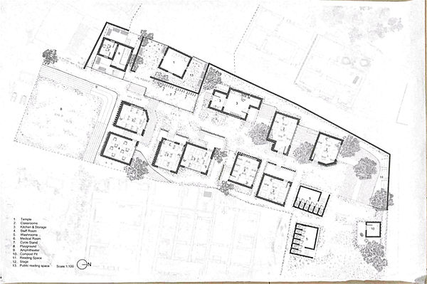
The temple is a main meeting point for everyone. Around the temple, I’ve added seating for the public to use. This area also serves as the main entrance for the school and a comfortable waiting area for parents. By making the temple a shared space, the school feels more connected to the village, and the entrance becomes a busy, welcoming spot for both students and locals. I want the playground to serve more than one purpose. While it’s mainly a place for kids to play, I’ve designed it so it can also be used as a ceremony hall for the village. Whether it's for school events or community celebrations, this open space acts as a flexible hub that can adapt to different needs throughout the year.
The following are programme diagrams :


Site Analysis

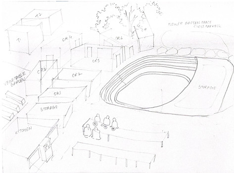
The site was analysed by looking at how the sun and wind move across it. We also studied how people walk through the area (circulation), where the buildings are located (massing), and where the main social gathering spots (public nodes) are.
Design Process

I chose to focus on the pattern of how main streets branch into smaller alleys used by the community. At first, I tried putting large building blocks on the site, but it took up too much room and the gaps between the buildings didn't feel useful. I realized that instead of just 'placing blocks,' I needed to design the spaces between them to work like the village alleys, making the layout feel more natural and efficient.

In my second design iteration, I developed the layout around a central spine that originates at the entrance and branches out to connect all the school buildings. This main arterial path acts as a guide through the campus, while the spaces between the classrooms form narrow, intimate alleys for student play and social interaction. Moving away from a single, distant garden, I integrated decentralized garden pockets directly into each classroom's footprint. This allows students to take daily responsibility for their plants, fostering a 'farm-to-table' connection as the herbs and vegetables they grow are harvested for their school meals.
Final Plan

Process Models



Sections
End wall section (1:25)

Model


Views


